Building or renovating a home near the shoreline comes with unique challenges and responsibilities. One of the most critical aspects is understanding coastal home elevation requirements. These regulations are designed to protect properties, residents, and communities from flooding, storm surges, and the long-term effects of coastal erosion. Whether you are a homeowner, builder, or real estate investor, knowing the essentials of elevation standards can help you make informed decisions and avoid costly mistakes.
In addition to safeguarding your investment, adhering to elevation guidelines is often a prerequisite for obtaining building permits, insurance coverage, and even resale value. This article will break down the key factors that influence elevation mandates, how to interpret flood zone maps, and what steps you need to take for compliance. For those interested in pet-friendly coastal living, you might also want to explore jupiter dog beach reviews for pet owners to make the most of your beachside experience.

Why Elevation Standards Matter for Coastal Properties
Coastal regions are particularly vulnerable to flooding, hurricanes, and rising sea levels. Local and federal agencies have established coastal home elevation requirements to minimize the risk of property damage and loss of life. These standards are not arbitrary; they are based on scientific data, historical flood records, and predictive modeling.
Elevating homes above the predicted flood level helps to:
- Reduce the likelihood of water entering living spaces during storms or tidal surges
- Lower insurance premiums by demonstrating compliance with floodplain management rules
- Increase the long-term resilience and value of the property
- Meet local building codes and obtain necessary permits
Failing to meet elevation standards can result in denied permits, higher flood insurance costs, and increased vulnerability to severe weather events.
Key Factors Influencing Elevation Rules
The specific requirements for raising a coastal home depend on several factors. Understanding these variables is essential for planning your project and ensuring compliance.
- Flood Zone Designation: The Federal Emergency Management Agency (FEMA) produces Flood Insurance Rate Maps (FIRMs) that classify areas into zones such as AE, VE, and X. Each zone has its own minimum elevation, known as the Base Flood Elevation (BFE).
- Local Building Codes: Municipalities may enforce stricter guidelines than federal standards, especially in areas with a history of severe flooding.
- Proximity to Water: Homes closer to the ocean, rivers, or bays often face higher elevation mandates due to increased exposure to storm surges.
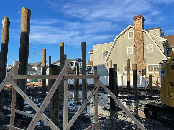
- Type of Construction: The foundation style (e.g., pilings, piers, slabs) affects how elevation is measured and achieved.
- Historical Data: Previous flood events and erosion patterns can influence local authorities to adjust elevation requirements.
Understanding Flood Zones and Base Flood Elevation
One of the first steps in determining how high to elevate your coastal home is to identify your property’s flood zone. FEMA’s maps are the primary resource for this information. The Base Flood Elevation (BFE) is the computed elevation to which floodwater is anticipated to rise during a base flood (a flood with a 1% chance of occurring in any given year).
Here’s how different flood zones impact elevation planning:
- Zone AE: These areas are subject to inundation by the 1% annual chance flood. Homes must be built at or above the BFE.
- Zone VE: These are coastal high hazard areas with additional requirements for structural support and elevation due to wave action.
- Zone X: Areas outside the 1% annual chance floodplain, usually with less stringent elevation rules.
It’s important to consult your local building department for the latest maps and any amendments that may affect your property.
How to Comply with Coastal Elevation Mandates
Meeting coastal home elevation requirements involves more than just raising the structure. Here’s a step-by-step overview of the compliance process:
- Obtain a Flood Zone Determination: Use FEMA’s online tools or consult with a surveyor to confirm your property’s flood zone and BFE.
- Hire a Licensed Surveyor or Engineer: Professional guidance ensures accurate elevation measurements and helps avoid costly errors.
- Choose the Right Foundation: Options include pilings, piers, or elevated slabs. The choice depends on soil conditions, flood risk, and local codes.
- Secure Permits: Submit your elevation plans to the local building department for approval.
- Schedule Inspections: Most jurisdictions require inspections at various stages to verify compliance.
- Obtain an Elevation Certificate: This document is essential for insurance purposes and future property transactions.
For a deeper dive into construction materials suited for harsh environments, see this comprehensive guide on building materials for coastal homes.

Common Challenges and Solutions
Navigating the complexities of elevation rules can be daunting. Here are some common obstacles and practical solutions:
- Changing Flood Maps: FEMA periodically updates flood maps, which can alter your property’s requirements. Stay informed and be proactive in checking for updates.
- Cost of Elevation: Raising a home can be expensive, but grants and low-interest loans may be available through state and federal programs.
- Design Constraints: Elevating a structure can impact accessibility and aesthetics. Work with architects experienced in coastal design to balance safety and style.
- Insurance Implications: Non-compliance can lead to higher premiums or denial of coverage. An elevation certificate is often required for the best rates.
Tips for Homeowners and Builders
Whether you are building new or retrofitting an existing property, consider these best practices:
- Plan for Future Sea Level Rise: Elevate above the minimum required level to account for long-term changes.
- Use Durable Materials: Select materials that withstand salt, wind, and moisture. For more on this, refer to the external guide linked earlier.
- Work with Local Experts: Engage professionals who understand the nuances of local codes and environmental conditions.
- Document Everything: Keep thorough records of surveys, permits, inspections, and certificates.
- Stay Engaged in Community Planning: Participate in local meetings and stay informed about policy changes that could affect your property.
Frequently Asked Questions
How do I find out the required elevation for my coastal home?
Start by checking FEMA’s Flood Insurance Rate Maps (FIRMs) for your area. Your local building department can also provide the latest information on flood zones and minimum elevation levels. Consulting a licensed surveyor is recommended for precise measurements.
What happens if my home does not meet elevation standards?
Non-compliance can result in denied building permits, increased flood insurance premiums, and greater risk of property damage. In some cases, you may be required to retrofit your home to bring it up to code.
Are there financial assistance programs for elevating homes?
Yes, various grants and low-interest loans are available through federal, state, and local agencies. Programs like FEMA’s Hazard Mitigation Grant Program can help offset the cost of elevation projects.
Can elevation requirements change over time?
Absolutely. Flood maps and local ordinances are updated periodically based on new data and environmental changes. It’s important to stay informed and review your property’s status regularly.
Conclusion
Understanding and meeting coastal home elevation requirements is essential for protecting your property and ensuring compliance with local and federal regulations. By staying informed, working with experienced professionals, and planning for the future, you can enhance your home’s safety, value, and resilience against coastal hazards. For those who enjoy coastal living with pets, don’t forget to check out resources like jupiter dog beach reviews for pet owners for additional tips on making the most of your seaside lifestyle.